Tennessee River Floods
Chattanooga’s History

The Tennessee River Floods Redefine Chattanooga’s Neighborhoods
How can a river’s unpredictable nature transform the character and resilience of a city? For Chattanooga, the Tennessee River has long been a defining force, its tranquil beauty matched only by its potential for powerful flooding. Each of the Tennessee River floods, while challenging, has left an indelible mark on Chattanooga’s neighborhoods, forging a path of resilience, adaptation, and renewed appreciation for the river’s dual nature. In this post, we’ll explore how Chattanooga has responded to the Tennessee River floods, creating a legacy of enduring strength, innovation, and community spirit.
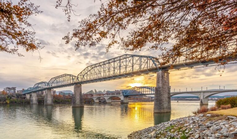
Chattanooga’s Connection to the Tennessee River: Beauty Meets Power
The Tennessee River’s expansive reach has been central to Chattanooga’s development, shaping not only its economy but also its culture. Its beauty and utility have made it a symbol of life and prosperity, attracting tourism, commerce, and even the vibrant recreational community. However, the potential for Tennessee River floods remains a reminder of nature’s unpredictability.
While the river’s serene appearance has drawn people to its shores, Tennessee River floods have historically posed real threats to those living nearby. These events have repeatedly tested Chattanooga’s resilience, calling for long-term adaptations and a deeper understanding of the river’s impact on daily life. [Reference: Visit Chattanooga Article]
A History of Tennessee River Floods in Chattanooga: Turning Points of Tragedy and Transformation
1. Pre-1900 Floods: The Great Flood of 1867

Among the city’s most challenging Tennessee River floods was the Great Flood of 1867, one of the most devastating events in Chattanooga’s pre-1900 history. This flood not only left the city under several feet of water but also reshaped Chattanooga’s relationship with the Tennessee River, marking a pivotal moment that would guide future infrastructure and community resilience efforts.
In March of 1867, the Tennessee River rose to unprecedented levels, swelling nearly 58 feet above its usual height, a mark that still stands as one of the highest flood stages in the city’s history. Consider the worst of the Tennessee river floods in the Chattanooga area. Heavy rainfall combined with melting snow from the Appalachian region created an overwhelming force of water that surged into Chattanooga’s low-lying areas.
Neighborhoods near Ross’s Landing—a central hub in Chattanooga and one of the city’s most historically significant locations—were among the hardest hit. What we know today as the downtown area became a watery expanse, with many buildings nearly submerged as the river spread into streets and local properties.

Courtesy of the Chattanooga Public Library.
Chattanooga’s only bridge, the Military Bridge, which connected the north and south shores of the Tennessee River, was destroyed by the force of the rising waters. This vital structure, crucial for transportation and trade, was swept away, further isolating residents and making recovery efforts even more challenging for those on both sides of the river.

The Great Flood of 1867 dealt a heavy blow to Chattanooga families, homes, businesses, and public spaces. The Tennessee River’s banks were obliterated, and buildings along the waterfront suffered extensive damage, with some structures facing near-total destruction. One notable example was the Crutchfield House, a significant local landmark that served as a hotel and gathering place for residents. During the flood, it became a refuge for those displaced, though it too endured severe damage as the floodwaters rose around it.
Countless residents lost their homes and personal belongings in the flood, with entire family estates devastated or swept away by the relentless surge. While the exact number of lives lost remains unknown, eyewitness accounts describe the harrowing sight of bodies floating down the river for days, a somber reminder of the flood’s tragic toll on the community.
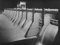
The flood of 1867 left an indelible mark on Chattanooga and is recognized as the greatest of the Tennessee River Floods. The community was forced to consider new ways to protect its citizens from the Tennessee River’s unpredictable rises. Although flood management infrastructure was rudimentary at best in the years following this disaster, the memory of the Great Flood played a role in later decisions that would reshape Chattanooga. For instance, the construction of the Chickamauga Dam decades later would owe, in part, to Chattanooga’s historical Tennessee River floods experiences and the desire to control the Tennessee River floods, adding safety and security of the growing city.
2. The 20th Century Floods: An Era of Reckoning and Reform
For much of its early history, Chattanooga has battled the mighty Tennessee River floods, tendency to rise and inundate the city’s low-lying areas. The early 20th century marked a particularly challenging time for Chattanooga as the city experienced a series of devastating floods, the most significant being the Tennessee River floods of 1917 and 1938. These events left an indelible mark on the city’s landscape and reshaped its approach to infrastructure, ultimately leading to the establishment of the Tennessee Valley Authority (TVA) and a lasting legacy of flood control.
The 1917 Flood – Scope and Impact

In the early spring of 1917, Chattanooga faced one of the most catastrophic floods in its history. On March 7, torrential rain caused the Tennessee River to surge past its banks, engulfing large parts of the city. The river’s overflow submerged areas across the Southside, Downtown Chattanooga, and neighboring regions like Rossville, leaving an enduring mark on these communities. As water levels rose, iconic landmarks such as the Walnut Street Bridge faced overwhelming damage. Bridges and key buildings in Chattanooga’s bustling business district were compromised, disrupting daily life and halting economic activities.
The lasting impact of the 1917 flood went beyond physical damage. The flood catalyzed early discussions among local officials about Chattanooga’s vulnerability and the pressing need for permanent flood control measures. Though no large-scale infrastructure was immediately implemented, this event planted the seeds of reform that would eventually shape the city’s approach to flood management. Additionally, the collective trauma of the 1917 flood fostered a strong community spirit, uniting residents and reinforcing their resolve to advocate for significant structural changes.
The 1938 Flood – A Devastating Downpour
Nearly two decades after the 1917 flood, Chattanooga was once again at the mercy of the Tennessee River floods. This time, a three-hour cloudburst on the night of August 4–5, 1938, brought more than 12 inches of rain a couple hours north of Chattanooga. The torrential downpour caused the river to rise a staggering 28 feet above flood stage, quickly turning Chattanooga’s streets into rivers. The rain, coupled with the city’s already flood-prone geography, created an overwhelming situation as water levels surged over previously established flood zones and engulfed neighborhoods and key commercial areas.
This 1938 flood brought catastrophic damage to landmarks, homes, and infrastructure across the city. Several bridges, already strained from the day-to-day use, collapsed under the pressure of the floodwaters, isolating entire parts of Chattanooga and adding to the chaos. Residential neighborhoods, particularly those in Downtown and surrounding low-lying areas, were hit the hardest, with thousands of residents forced to flee their homes in a hurried evacuation. Over 4,000 people relocated to higher ground, seeking refuge from the surging waters and the uncertainty that accompanied this natural disaster. The flood left a somber imprint on the community as families and business owners contended with loss and property damage, some beyond repair.
The cumulative damage of the 1938 flood, compounded by the memory of past Tennessee River floods, fueled Chattanooga’s determination to establish a permanent solution to its flood problem. This time, the city’s resolve for reform was stronger than ever, and public sentiment coalesced around the need for systematic change. The flood emphasized the importance of federal involvement in local flood management efforts, and, ultimately, it set in motion the steps that led to the creation of a lasting solution for the Chattanooga area.
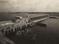
Lasting Reforms and the Legacy of the TVA
The Tennessee River floods of the early 20th century had a profound impact on Chattanooga, prompting both state and federal responses to mitigate future disasters. In 1933, as part of the broader New Deal initiatives, the Tennessee Valley Authority (TVA) was established, marking a turning point in Chattanooga’s approach to flood control. Although the TVA’s formation predated the 1938 flood, the severity of that event solidified the need for comprehensive flood management. One of the TVA’s most pivotal projects, the Chickamauga Dam, was completed just a few years later. This dam, along with the TVA’s extensive reservoir system, became a crucial line of defense against the Tennessee River’s rising waters.
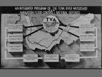
Today, the TVA’s flood control efforts stand as a testament to Chattanooga’s resilience and adaptability. By preventing an estimated $4.9 billion in flood damage over the years, the TVA has not only protected Chattanooga’s infrastructure but also fostered economic stability and allowed the city to grow without the constant threat of Tennessee River floods. Thanks to these reforms, Chattanooga has transformed from a city vulnerable to frequent, devastating floods to a community that can weather even the harshest storms.
3. 21st Century Floods: The 2003 Flood and Ongoing Challenges
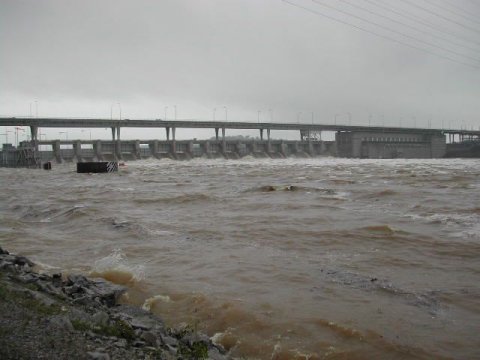
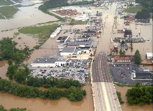
Another one of the devastating Tennessee River Floods began in early May of 2003, after days of heavy rainfall that started the previous Sunday. By midweek, water levels had surged far beyond the norm, with the Tennessee River reaching a daunting 36 feet near the Walnut Street Bridge—six feet above flood stage. Chattanooga, like many other cities, had experienced floods before, but the ferocity of this event was a somber reminder of the city’s vulnerability to the forces of nature. The floodwaters, flowing well into the following week, brought Chattanooga to a standstill.
Landmarks and Infrastructure Underwater
As floodwaters swept through Chattanooga, the Tennessee Valley Authority (TVA) warned of ongoing peril from excess runoff, a prediction that tragically held as high water levels submerged neighborhoods near the river and South Chickamauga Creek, leaving iconic landmarks like the Walnut Street Bridge and countless other structures and streets partially or completely inundated, transforming much of the city’s familiar landscape into an unrecognizable floodplain.
The financial toll was daunting. TVA officials estimated the damage at approximately $17 million, with around 480 structures affected. Residential neighborhoods were especially hard-hit, with homes suffering extensive water damage that, in many cases, would require complete renovation. Roads and utilities also took a blow, as temporary barriers and infrastructure buckled under the flood’s persistence, showing how under prepared the city was for a deluge of this magnitude.
Community Impact and Evacuations
Courtesy of Weather.gov
The flood’s impact extended far beyond property damage. In the wake of the rising waters, approximately 1,000 people were forced to evacuate from their homes, particularly in suburban neighborhoods hit hardest by the flood. Some sought refuge with friends and family, while others turned to temporary shelters. Hamilton County Emergency Services set up a makeshift shelter at a local high school, providing safe haven for 26 residents who had nowhere else to go as they waited for the floodwaters to recede.
Among the displacement and disruption, the flood also brought tragedy. At least one fatality was reported, a heartbreaking loss that underscored the severity of the situation and the unpredictability of nature’s force. “Residents just need to stay home,” warned emergency services spokeswoman Amy Maxwell, as Chattanooga’s emergency teams rallied to prevent further casualties, evacuating homes, and assisting the stranded in what became an all-hands effort to manage the crisis.
Government and Community Response
In response to the 2003 flood’s devastation, the Tennessee Valley Authority and local government mobilized to aid recovery, allocate resources for repairs, and initiate discussions on long-term flood control, spurring Chattanooga’s leaders and residents to strengthen infrastructure and prioritize preventive measures, marking a pivotal moment of resilience and reform to protect the city from future disasters.
Tennessee River Floods Preparing for the Future:
Flood Prevention and Modern Adaptation
Real Estate and Resilience: What Tennessee River Floods Mean for Buyers
In a city shaped by the history of Tennessee River floods, understanding the risks and opportunities of riverfront living is essential. Flood insurance, resilient construction, and expert real estate advice are invaluable to prospective buyers. Knowledgeable Realtors at Jay Hudson Homes – Keller Williams bring insight into Chattanooga’s flood zones, helping clients make informed, secure choices. By balancing the river’s allure with precautionary measures, residents can enjoy all that Chattanooga has to offer while staying safe and prepared.
Embracing Resilience by the Tennessee River
The Tennessee River’s beauty and power, as seen through its history of floods, have shaped Chattanooga’s identity, challenging its people to grow, adapt, and thrive. Each instance of Tennessee River floods has been an opportunity to learn and strengthen, building a community that values resilience as much as it values the natural beauty of the river. Today, Chattanooga’s neighborhoods stand as testaments to the city’s strength, innovation, and preparedness.
If you’re interested in joining this vibrant community, our experienced Realtors can guide you through Chattanooga’s unique neighborhoods, helping you find a home that’s both beautiful and resilient along the iconic Tennessee River. Give us a call at 423-702-0116.
We would like to express our gratitude to the following articles for providing valuable information that contributed to this article Tennessee River Floods:
- https://www.weather.gov/mrx/may03flood
- https://www.ocala.com/story/news/2003/05/10/floodwaters-that-killed-one-begin-to-recede/31278893007/
- https://www.chattanoogan.com/2003/5/8/36201/Flood-Damage-Up-To-17-Million-As-480.aspx
- https://cityscopemag.com/city-scope/ask-hamilton-24/
- https://www.timesfreepress.com/news/2016/jan/24/moore-flood-1917/
- https://en.wikipedia.org/wiki/Underground_Chattanooga
- https://en.wikipedia.org/wiki/1867_flood_of_Chattanooga
- https://www.timesfreepress.com/news/2019/nov/23/moments-memory-chickamauga-dam/
- https://www.timesfreepress.com/news/2017/mar/05/150-years-ago-week-tennessee-river-rises-58-f/
- https://www.visitchattanooga.com/blog/post/whats-hiding-in-the-tennessee-river/
- https://www.chattanoogan.com/2023/3/4/465119/John-Shearer-Remembering-Horrific.aspx
When else did the Tennessee River reach flood stage in Chattanooga?
The Tennessee River also experienced notable floods in 1875, 1886, 1918, and 1973.
How can a Realtor assist with purchasing property near the Tennessee River in Chattanooga?
A knowledgeable Realtor can provide valuable insights into flood-prone areas, zoning regulations, and resilient properties. They can guide potential buyers through Chattanooga’s riverfront real estate market, helping them find homes that are both scenic and secure against potential flooding risks.
What flood management systems does Chattanooga have in place today to prevent similar disasters?
Today, Chattanooga relies on several flood management systems, most notably the Chickamauga Dam, which helps regulate the Tennessee River’s flow. Additionally, flood control measures and emergency preparedness systems have been established to mitigate the impact of high water levels.